Loading...

newsTicker.loading • newsTicker.loading
newsTicker.loading • newsTicker.loading
Loading...
EcoBangla Weather Center
October 11, 2025
255
0
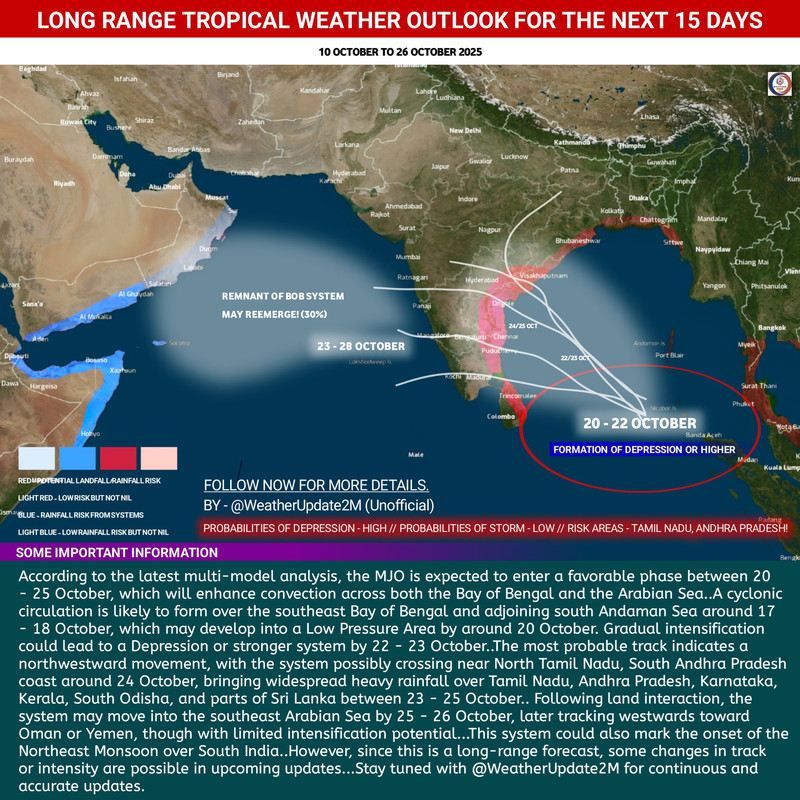
A Low Pressure Area (LPA) may form over the southeast Bay of Bengal around October 20, possibly intensifying into a Depression by October 22-23, according to long-range tropical weather forecasts. Heavy rainfall is likely over Tamil Nadu, Andhra Pradesh, Kerala, and Sri Lanka between October 23-25, with the system potentially entering the Arabian Sea later. The forecast, shared by Weather Update 2M, indicates that according to the latest multi-model analysis, the Madden-Julian Oscillation (MJO) is expected to enter a favorable phase between October 20-25, which will enhance convection across both the Bay of Bengal and the Arabian Sea.
A cyclonic circulation is likely to form over the southeast Bay of Bengal, originating south of the Andaman Sea around October 17-18. This system may develop into a Low Pressure Area by around October 20, with gradual intensification possibly leading to a Depression or stronger system by October 22-23. The most probable track indicates a northwestward movement, with the system possibly crossing near North Tamil Nadu or South Andhra Pradesh coast around October 24. This could bring widespread heavy rainfall over Tamil Nadu, Andhra Pradesh, Karnataka, Kerala, South Odisha, and parts of Sri Lanka between October 23-25. However, meteorologists caution that since this is a long-range forecast, some changes in track or intensity are possible in upcoming updates. The situation requires continuous monitoring as the system develops. Risk areas identified include Tamil Nadu and Andhra Pradesh, which may experience the most significant rainfall and potential storm impacts.


While the primary impact zone appears to be India's southern and southeastern coasts, weather systems in the Bay of Bengal can have cascading effects on Bangladesh's flood situation. Any significant rainfall enhancement in the region could affect water discharge patterns in shared river basins. Bangladesh is currently dealing with multiple flood emergencies, with monitoring stations in Barishal, Daulatkhan, and Dalia at Warning Level, and Kaunia in Rangpur district exceeding the danger mark. The Brahmaputra River system remains particularly sensitive to any additional water input from upstream regions. The timing of this potential cyclonic system coincides with the late monsoon period, when Bangladesh's northern districts are already experiencing elevated water levels due to upstream rainfall in India's northeastern states and discharge from Himalayan catchments. Climate scientists note that the Bay of Bengal remains one of the world's most active cyclone-forming regions, with warming ocean temperatures potentially contributing to more frequent and intense tropical systems. For climate-vulnerable nations like Bangladesh and coastal communities across South Asia, enhanced forecasting capabilities and early warning systems remain critical for disaster preparedness.
Join the conversation and share your thoughts!
Be the first to share your thoughts!